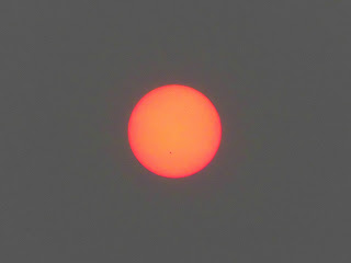
Weather and Fire
It's a little hard to think about birds, turtles, and trees today when the dominant nature event this week has been the hazy/smoky conditions resulting from Canadian wildfires. My impression is that both New Brunswick and Quebec have wildfires causing these conditions.
Yesterday morning I woke up to cool, hazy conditions but some actual sunlight. The radio warned me that the air quality wasn't good, and that people should limit strenuous activities, especially outdoors. But conditions didn't seem all that different from normal, so I did my usual morning jog [2]. I did shorten my route a little for caution's sake (and felt fine afterwards).
 |
| June 6, 2023 |
As the day progressed, things appeared to get worse. I couldn't see shadows at all, and the hazy conditions extended down to ground level, giving the appearance of fog in the middle of the day [2]. I've lived in the northeast my entire life and don't remember seeing a day like this before. I suspect this day would have been very familiar to the people living downwind of the wildfires that have plagued the west coast in recent years, but it was new to me.
With both the news and visual cues telling me how bad the air was, I did something I hadn't done in a while now. When I went to run errands (driving to Costco and walking to the pharmacy) I wore an N95 mask outside [3]. Who knew that preparations for COVID would be helpful for future weather conditions?
I can't vouch for the integrity of this map. I took the image this morning and it was supposed to show the then-current air quality for localities near me. Somerville (which is very close to the part of Bridgewater in which I live) is in a little triangle of reporting stations:- Chester (31 in Green), signifying Good air quality.
- Flemington (196 in Red), signifying Unhealthy air quality.
- Rutgers (198 in Red), also signifying Unhealthy air quality.
 |
| Local Air Quality - June 8, 2023 around 12:30 PM |
Here's a map of the Canadian wildfires. (Note that fires crossing the US border probably wouldn't be on this map. Note also that this map is probably a couple days out of date.) There are a couple things that surprise me:
- The Quebec fires are probably 500+ miles away, and the New Brunswick fires are probably 400+ miles away. That seems like a long way for dissipating smoke to travel.
- Usually I'd expect NJ weather to come more or less west of us, with the main exception being storms coming from the south and up the coast. The smoke seems to be coming from an unusual direction. I'm going to guess that the fires themselves are responsible for the unusual wind patterns.
- If the fires are causing wind to blow from the north and/or northeast, that might be part of the reason why it's been kind of cool the last few days. (I'm sure the PM2.5 is blocking sunlight too; this might be the primary cause for cooler temperatures.)
- Canada (and NJ) had an unusually dry spring, and this is something climate change is wont to do.
- A naive view of fire ecology may have "backfired" on us, with fire suppression efforts resulting in more forest fuel that allows bigger wildfires.
[1] I'm not a fast jogger, especially these days. It's arguable that it doesn't really qualify as strenuous activity. 😄
[2] Given the cool temperatures, it would have felt pretty clammy if that was really fog.
[3] At least I think it was an N95 mask. When I bought it, I thought the set was of KN95 masks, the Chinese equivalent that's theoretically just as good, but the masks are labeled as N95 masks.


Comments
Post a Comment